Mount Ruang eruption: Why flights in Malaysia are getting cancelled
This morning, Malaysia Airlines and AirAsia announced flight cancellations to East Malaysia due to the Mount Ruang eruption. — All SoyaCincau pics
Join us on our WhatsApp Channel, follow us on Instagram, and receive browser alerts for the latest news you need to know.
By Alexander Wong
Thursday, 18 Apr 2024 3:20 PM MYT
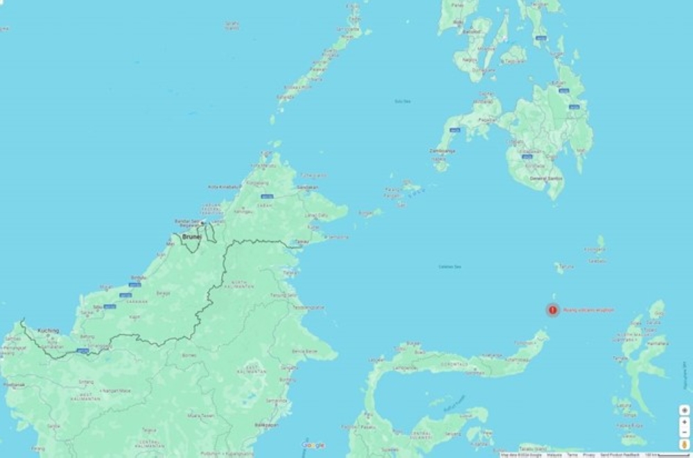
KUALA LUMPUR, April 18 — This morning, Malaysia Airlines and AirAsia announced flight cancellations to East Malaysia due to the Mount Ruang eruption. If you look at Google Maps, the volcano eruption is about 800km from Malaysia. Some might ask, why did a disaster in North Sulawesi in Indonesia disrupt air travel to Sabah and Sarawak?
What is Mount Ruang eruption? Where is it located?
According to the Civil Aviation Authority of Malaysia (CAAM), Mount Ruang is a stratovolcano located at N0218 E12522 near Manado in North Sulawesi province in Indonesia. The recent incident first erupted at 9.45pm on Tuesday, followed by four times more throughout Wednesday.
Mount Ruang Volcano Eruption in North Sulawesi. Source: Google Maps
Advertisement
Following the eruption, volcanic ash clouds have been observed within the Kota Kinabalu Flight Information Region (FIR) and it is seen as a significant risk to aircraft safety. At 6.00am, the Malaysian Meteorological Department issued a Significant Meteorological (SIGMET) 1, indicating ash clouds moving westerly at a speed of 30 knots from the surface to 55,000 feet and intensifying.
Why do volcanic ash clouds disrupt flights in Sabah, Sarawak, Labuan and Brunei?
As mentioned by CAAM in their Safety Information, volcanic ash clouds can cause severe damage to aircraft engines and aircraft systems which could then lead to potential engine failure, reduced visibility and damage to critical components. It added that volcanic ash can also interfere with aircraft avionics, posing a serious threat to flight safety.
Advertisement
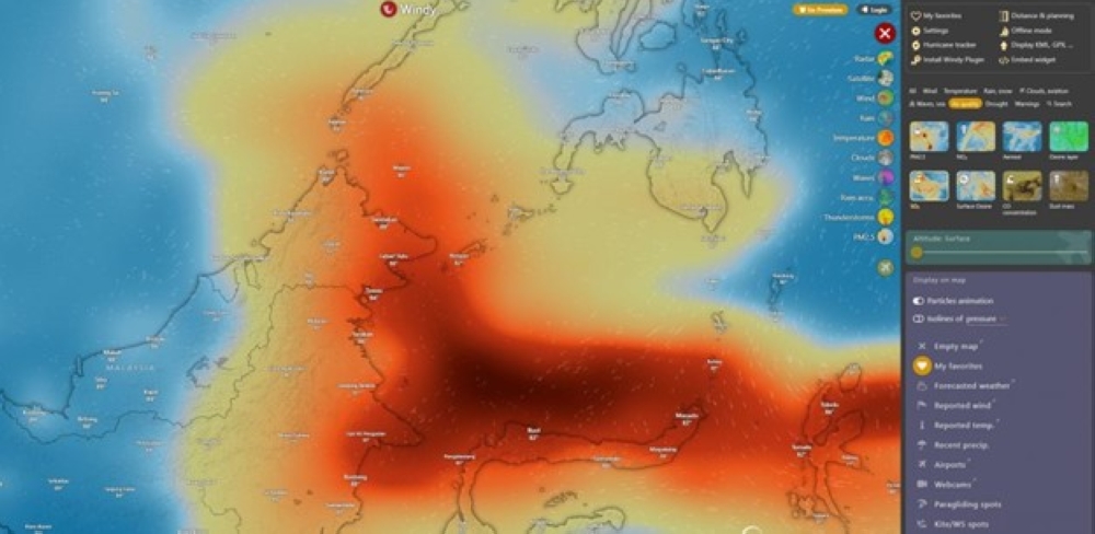
Map shows a high concentration of sulfur dioxide moving towards Kalimantan and Sabah. Source: Windy.com
It advised all aviation stakeholders to exercise extreme caution and implement appropriate measures to mitigate the risks associated with volcanic ash encounters.
The aviation regulator also provided a list of recommendations which include all air operators to closely monitor meteorological updates, volcanic ash advisories and Notice to Airmen (NOTAMs) issued by relevant authorities. It also reminded pilots to exercise vigilance and adhere strictly to established procedures and guidelines for avoiding volcanic ash encounters, including diverting flight paths, emergency response plans, altering altitudes and maintaining communication with air traffic control.
It also urged Airports within the affected area including Tawau and Lahad Datu to implement measures to mitigate the impact of volcanic ash on ground operations such as regular monitoring of runway conditions and implementing appropriate cleaning procedures.
As illustrated by the Windy map above, high sulphur dioxide (SO2) concentration from Mount Ruang can be seen heading towards East Kalimantan and Sabah. SO2 is one of the most common gases released during volcanic eruptions.
In 2010, a similar major air travel disruption occurred in Europe due to the Eyjafjallajökull eruption. Many European-controlled airspace were closed and it was described as the largest air-traffic shutdown since World War II.
Malaysia Airlines and AirAsia have cancelled flights for today
At the moment, Malaysia Airlines and AirAsia have cancelled flights to East Malaysia and are offering options to affected guests to switch to alternative flights. A few hours ago, AirAsia announced flight cancellations to nine airports on Borneo which include Kota Kinabalu, Tawau, Sandakan, Labuan, Miri, Sibu, Bintulu, Kuching and Brunei, until 8.00am tomorrow.
Over in Indonesia, authorities have ordered a shutdown of its international airport in Manado city on Sulawesi for 24 hours. On the ground, authorities are also rushing to evacuate 11,000 residents from the nearby area which included the remote island of Tagulandang which is home to about 20,000 people. — SoyaCincau


